


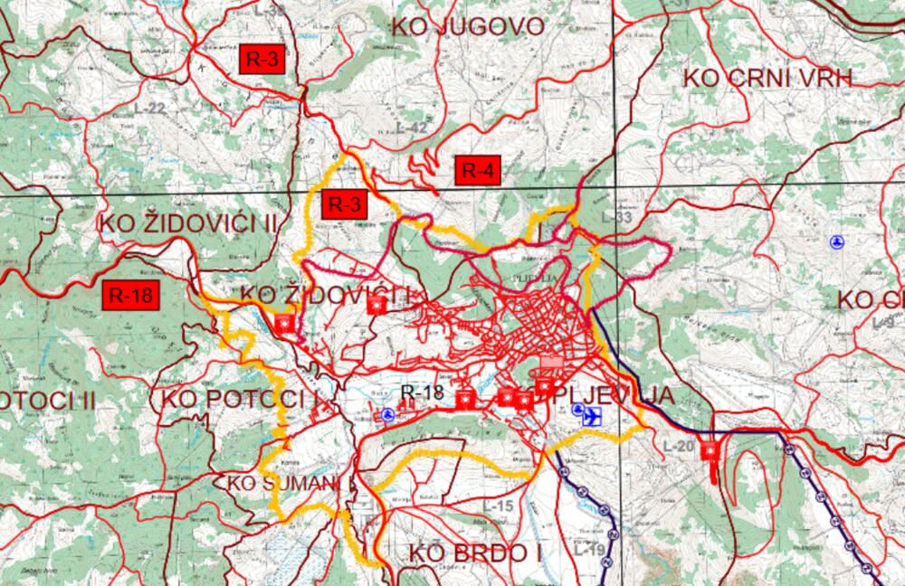
In the draft of the Spatial-Urban Plan for Pljevlja, which was adopted by the Government on March 15 and is currently under public debate, there is no mention at all of the announced high-speed road Crnča - Pljevlja - Goražde, for the conceptual solution of which "Monteput" announced a public call at the beginning of March , but the construction of an airport, two railway lines and seven locations for heliports is planned.
At the beginning of last week, "Vijesti" sent a question to the Ministry of Spatial Planning, Urbanism and State Property, why this road is not included in the draft PUP of Pljevlja, whether it will be added during the public debate on this spatial document, as well as whether what this road is not in the draft PUP, it may have a negative effect on the public invitation issued by Monteput, but from the department he heads Janko Odović they did not send a reply.
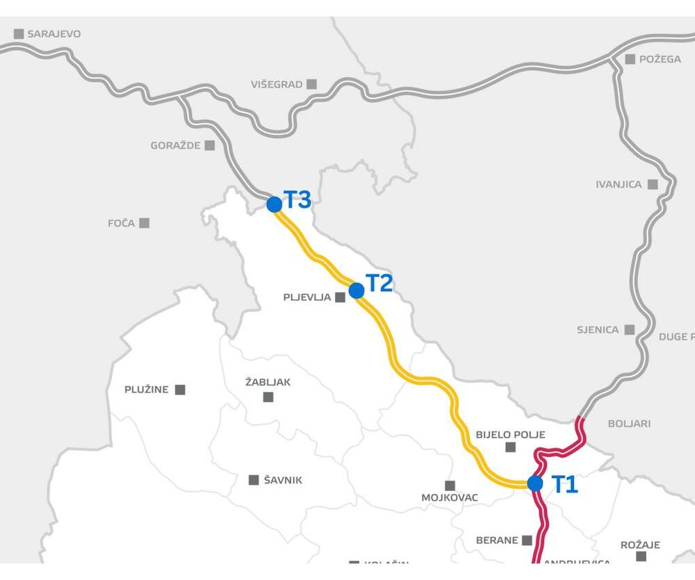
On March 4, "Monteput" announced a public call for the development of a conceptual design for the section of this high-speed road that starts from the town of Crnča in Bijelo Polje, where it intersects with the Bar - Belgrade highway, goes to Pljevlje, and then to Goražde in Bosnia and Herzegovina and beyond. towards Sarajevo.
The total length of this road through Montenegro is 93 kilometers, and the prime minister Milojko Spajic announced at the end of last year the shortest future connection between Sarajevo and Istanbul, because a new highway will go from Crnče to Peja in Kosovo, from where there will be highway routes through Kosovo, Macedonia and Greece to Turkey.
The relevant Ministry did not explain how it is possible to create a conceptual solution for an international expressway, which is not mentioned in the spatial plan that should be valid until 2040.
The public call for "Monteput" lasts 90 days, and the selected bidder will have the obligation to make a preliminary design of the expressway route within five months from the signing of the contract.
In the traffic part of the plan, for road traffic, there are two existing main roads: Ranche - Pljevlja - Đurđevića Tara and Pljevlja - Vrulja - Bijelo Polje, as well as several regional roads, which are expected to be modernized and improved.
Airport returned to the plan
The draft returned the airport in Pljevlja to the spatial plan, although it was not included in the base study. The airport was in the previous spatial plan.
"The base study for the preparation of the new Spatial Plan of Montenegro did not foresee an airport in the municipality of Pljevlja, without providing an analysis of the reasons for abandoning the development of this type of traffic. "Given that the location for the airport has already been determined, and studies and a general airport solution have been completed, this planning document retains the solution of the PUP Pljevlja from 2011," the explanation states.
The spatial plan that was valid until 2020 on the territory of the municipality of Pljevlja planned the "construction of an airport of at least category 3C". As explained, the airport is planned for special needs: recreational flying, sports flying and (seasonal) regional traffic, as well as for smaller business aircraft.
Category 3C involves servicing aircraft that are defined as aircraft with a wingspan of up to 36 meters, a width of the main landing gear of up to nine meters and a distance between the main landing gear and nose wheels of up to 18 meters.
"This planning document maintains the location of the airport adopted and reserved through the previous planning documentation. In the urban area of Pljevlja, the construction of a sports airport and a heliport is foreseen through the plan for the development of air traffic on the territory of the municipality, which would achieve better general traffic connectivity and the development of the municipality as a whole", the explanation stated.
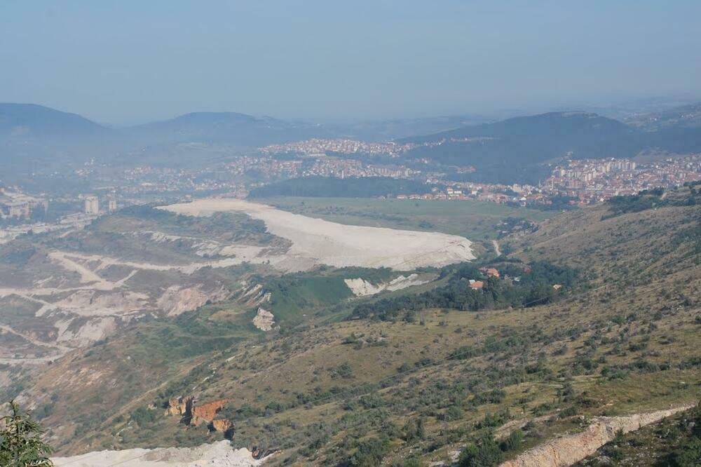
The PUP of Pljevlja from 2011 proposed a location on Potrlica, elevation 810, for the location of the future airport.
"For the purposes of determining the location of the future airport in the territory of the municipality of Pljevlja, the Institute of the Faculty of Traffic from Belgrade prepared a study 'Technical documentation - location documentation of the airport and heliport of Pljevlja', within the framework of which topographical, meteorological, navigational, constructional, traffic, ecological conditions as well as compliance with the existing planning documentation, and 'Technogradnja' from Pljevlja, in cooperation with the Faculty of Civil Engineering from Belgrade, the General solution of the airport complex", stated in the draft plan.
Helidromes in Bukovica, Šula, Crljenica...
The study "Technical documentation - location documentation of the airport and heliport of Pljevlja", as explained, considered the location of Kosanica "as another area in the area of Pljevlja that would provide some possibilities for a heliport".
"Analyses have established that the location enables the construction of a helicopter airfield along the existing Pljevlja - Lever Tara road. The airport would serve only as an alternative for the heliport in Pljevlja in situations where the heliport in Pljevlja would be closed for flying due to bad weather conditions. In addition to the analyzed and proposed locations of Potrlica and Kosanica, in order to better integrate space and increase the level of tourist services throughout the municipality, the possibilities of developing a heliport should also be examined at the following locations: the village of Bukovica, the village of Šula, the village of Kovačevići, the village of Bobovo and the village of Crljenice. it is stated in the explanation.
Heliports are marked on the spatial plan map in all these seven places.
Air show held in 1936, project actualized in 2006.
The first air-meeting in Pljevlja was held on August 28, 1936 at Pljevlja polje, when the collection of money for the construction of the airport began.
Recently, the idea was actualized by the former mayor of Pljevlja, Filip Vuković, in 2006, during the pre-election campaign for the presidential elections.
The event from 1936 was also the first aero-meeting in the Sandžak region, and the Belgrade press at the time reported that more than five thousand citizens from all over Sandžak had gathered, who came to see airplanes up close for the first time and enjoy the pilots' acrobatics.
Four planes took part in the meeting, two military planes from Sarajevo and one each from the Central Board and the Academic Aero Club from Belgrade.
In addition to various acrobatics, jumping from a plane with a parachute from a height of 1.000 meters, hunting for balloons, flying was organized for interested citizens.
According to media reports, Aero Club members paid 30 dinars to fly, and other citizens 40. For those who had a place to sit, the entrance fee was five dinars, standing was three dinars, and for children two dinars.
Immediately after the end of the welcoming speech of the then president of the Local Board, Dragiša Golubović, who emphasized the importance of aviation in peace and war, the first flights began. All the money collected from tickets was intended for the purchase of land for the airport in Pljevlja. However, it is not known if and where the land for the construction of the airport was purchased at that time.
During the election campaign for the presidential elections in 2006, Vuković announced the construction of an airport on the site of Đulina guk, on the reclaimed surface of the Potrlica mine of the Pljeval coal mine. The municipality also paid for the development of the main project for the construction of the airport, but the idea with which the government at that time often presented itself to the citizens was never realized.
On Potrlica, the take-off and landing runway, the dock complex...
The graphic attachment shows the location of the airport in the Potrlica area with the runway, taxiway, dock complex, fences, access road and helipad.
"Potrlica location (elevation 810 m above sea level) is located south of the center of Pljevlja, on the outskirts of the town, and it is about 900 m away from the city center as measured as the crow flies. This plateau was created by filling tailings from a coal mine, which has been stabilized, humunized and represents a green area," the document says.
They state that the airport would handle flights of sport planes, smaller business planes, gliders, motor kites and ultra-light aircraft coded 1A/B.
"The general solution of the airport at the Potrlica location contains the following elements: Grass runway measuring 950x30m (with preparation for asphalting in the next phase of construction) located in the basic runway measuring 1.020x70m; A grass connector for connecting the runway with a platform measuring 37,5x12m (with completed preparation for asphalting in the next phase of construction); Dock platform with asphalt pavement construction measuring 60x30m; Hangar platform with asphalt pavement construction measuring 30x20m; Tracks with asphalt pavement construction to fuel storage; An access road with parking lots with an asphalt pavement construction", the explanation specified.
Bonus video: